For the R2 sensor what would I expect in degraded performance if I was flying at 80m AGL and at 6m/s when compared to the optimum flight speed and altitude?
I came to ask a similar question - Looking for the optimal height/overlap/speed in various scenarios. Today I flew at 60m, 50% overlap and 11 mph in a wooded area and I’ll be processing soon. I do wonder what I could achieve on a more conceptual basis for contours, like in a county with no topo on a prospective land development site, could I fly say at 300 ft / very low overlap and fast to generate “good enough” topo? Would help to get a best practices FAQ or video on this. I have some construction sites that are wide open and I’d assume I can fly those faster / less overlap but don’t want to have to redo stuff.
Flying at about 50m AGL and 5-6 m/s is the optimal speed for getting sub 5 cm vertical accuracy.
The higher and faster you fly, the less accurate the readings of the sensor will be. However, there are more factors at play than just height and speed.
The reflectivity of the surface you are scanning also plays an important factor. Some surfaces have a harder time reflecting back to the sensor than others. For instance, we did a scan over some transmission lines in the desert:
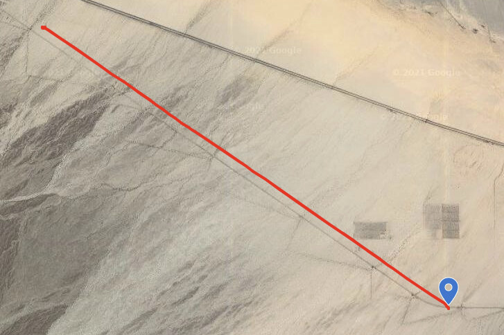
We were able to fly much higher and faster and still get sub 5 cm vertical accuracy because the surface reflected the light back to the sensor extremely well.
I will look to categorizing in a handy way our actual experiences with speed / height / reflectivity to give the community some more ideas on what to expect.
1 Like
Just checking back in on this to see how to establish some good flight parameters for different deliverables. I keep getting asked about “GIS Level” contours in rural areas on large tracts. Would love to fly this high and fast to just get some general idea of the land (better than USGS) but need to know the bare minimums to make things work. I’ve been flying at about 75m and 30% overlap and 15mph on my last few missions and with all my GCP’s I’ve been within 1-3 in, which is within our survey threshold. It is a time with almost no leaves though, and it doesn’t snow where I work. As the foliage comes in soon I’m sure I’ll have to be slowing down.
This is very relevant to my work also but I would like to fly higher and much faster, closer to 50mph and 150m. If we get this sort of study please do the analysis at other points beyond 75m and 15mph. Thanks
@Alex
I have a client that wants to fly between 5 and 10 meters AGL. They want to be able to measure the height of oats. Is this doable? If so any suggestions on speed etc.
@jmosher I don’t think you need to fly quite that low to get usable height measurements. I would start with 6 m/s. But, it very well may work just as well going 10 m/s. But, flying 5-10 m AGL @ 10 m/s sounds a bit too risky to me ;).
I haven’t personally flown over oats to capture lidar data. So, I would spend a couple of hours testing quick flights at different altitude / speed until you are happy with the density. Lidar picks up tall grass no problem, so ultimately it shouldn’t be an issue.
Would the LiVOX laser even distinguish that? Oats is often right around that 1m to 1.5m tall, which would be below the standard 2m gap for multi-return points.
Or would we need to rely on the single return density to indicate the tops and ground elevations?
At ~30ft AGL the beam from the LiVOX will make an oval on the ground 50mm high by 5mm wide if directly overhead. Out at the end of it’s 70d FOV at that AGL the beam’s dot is stretched to ~7mm wide.
already being wider than the typical plant spacing, at least in one direction, is it worth flying that low or is it better to fly higher, with a beam footprint closer to 15cm by 1.6cm and rely on the difference in intensity (ground vs plant)?
@jmosher
My farmer 2cents would be to fly medium height (100-150ft agl), with A LOT of overlap (>75%), given the columnar nature and density of the grassy plants, I don’t think speed will matter much as long as you are not spreading out the laser’s passes directly under the sensor too much (think scan frequency for vertically rotating sensors). Your overlap will be your key since you want to both see down the stocks of the plant and skim the tops of them. Flying that low given the beam’s footprint wouldn’t seem to help much in my mind… but am eager to be proven wrong.
I’d love to hear how this goes… messy grass is my nemesis.
2 Likes
Alex, Would it be possible to have a “LiDAR/photogrammetry” combination calculator similar to PropellerAero? I just purchased a R2A and plan to use orthophotos and LiDAR derived contours. I’m hoping to use the facade option as well.
Their calculator works well for photogrammetry, but adding variables for LiDAR would be a killer app.
1 Like

Yes, that’s the Propeller Aero GSD calculator. But I was suggesting that calculator PLUS being able to enter the LiDAR (R2A) parameters like AGL and speed (meters per second), the type of terrain like percentage of grassy, brush, wooded area. Also maybe include the height difference between the highest and lowest ground level of the flight area. The purpose would be for people new to LiDAR to have a guide to getting an estimate of good results like contour within ASPRS specs. I guess in a way I’m asking for an “expert with experience” to provide some guidance for flight planning/success planning. Big ask or a challenge? 
@Tim you tell me… What kind of challenges does this present?
Hi Tim, I guess the easy part is the GSD calculator because of known inputs/parameters. As I just ordered the R2A, I have zero LiDAR experience. That’s the hard part for me. Can the LiDAR “target results” be calculated in a similar manner or just fly everything at 50M AGL and 3 to 6M per second?
Or are ground conditions so variable it would be too hard to estimate LiDAR returns or coverage?
Can we upload Harrison & Alex and others to a portable “smart box”. LOL I’m excited to get started with the R2A, but just feeling the nerves a little.
1 Like
@RR_Flight_Ops We would just need to know the calculation and the parameters but we can chat about that and throw this in the backlog for the future.
Stay Tuned!
1 Like
Hi mdouglas,
I was once in your position…
- There is a learning curve. Sounds like you already know photogrammetry, so pretend your lidar is the same deal.
- Go out and fly known quantities. You will experience some failures, some success and I am betting before your 10th flight… you too will be an expert.
- Our job sites and the different flight scenarios are just that… Your experience after a few missions and failures will help you dial yourself in just perfect. Really.
- We fly all types of terrain. If it is flat and boring, 60m with a steady 6-7m/s gets really good results. When the terrain is changing elevation and material types, slow down… fly lower… You will learn how your lidar collects hundreds of millions of points, the density and workflow to make the data you need for your clients.
- I recently flew 150 acres of future development. I generated +/-150,000,000 points flying 60m AGL at 7m/s The original topo that was released to us from the client had 1000 points. Let’s say you did not cover everything or there is a small gap?? Depending on what you are comparing against, its not that bad!
- Rule of thumb… fly with 30% overlap unless you need overkill on your point cloud density.
- The Rock Community is an awesome place to ask questions so we can all learn.
Good flying!
2 Likes
@FlyingRadioWaves, Ray, Thanks for the great, very helpful tips and the vote of confidence. I’m a small (1 man) company so I’m the “IT” guy for everything. The R2A and the great folks at Rock Robotic is the reason I decided I could take the leap to LiDAR. Started in 2016 with an Inspire 1 Pro & 16mp X5. Tweaked some X5 settings and can get close to 1cm GSD. Biggest help are the 10 AeroPoints. My largest job was 130 acres…lots of batteries.
Graduated to the M300 RTK & 45mp P1 in February 2021 and now R2A LiDAR will be here Monday.
My engineering and surveying clients have been very pleased with orthophotos, but LiDAR would have been great $ for contours for the last 2 years…Central KY has lots of hills, trees & brush. Doing some construction/earthworks and some pre/post volumetric.
I appreciate your insights and wish you great success with your work as well.
It’s great to have a (Rock Robotic) community where everyone tries to help each other out! @RR_Flight_Ops @Tim
Mike D, GISP, UAV Pilot, Pix4Dmapper certified, CAD tech, photographer, other duties as assigned
1 Like