My project seems complete except I don’t have any ground points.
As you can see in this image the part of the road does not have any points at all,
how do I fix this? Thank you so much!

@Athena how high / fast did you fly?
LiDAR works by capturing reflected light when the laser pulse reflects off of the subject it hits. Very low reflectivity objects (very black roads for instance) reflect very little light. You can attempt to maximize your chances of collecting data on low-reflectivity objects by flying slower and lower.
Hi! my Altitude was just 150 and speed is 10m/s
Should I still go lower than this? Its a fairly clear area
150m or 150ft? I am assuming ft… but just wanted to verify since 150m AGL would be REALLY high for capturing a road surface and I am not sure what legal structure / FAA Rules you’re operating under.
10m/s is pretty quick for asphalt or low reflectivity surfaces. When we fly newish or clean black roads, we fly below 15mph… usually closer to 11-12mph since we are effectively relying on the luck of that laser hitting a rare reflective spot/rock on the surface.
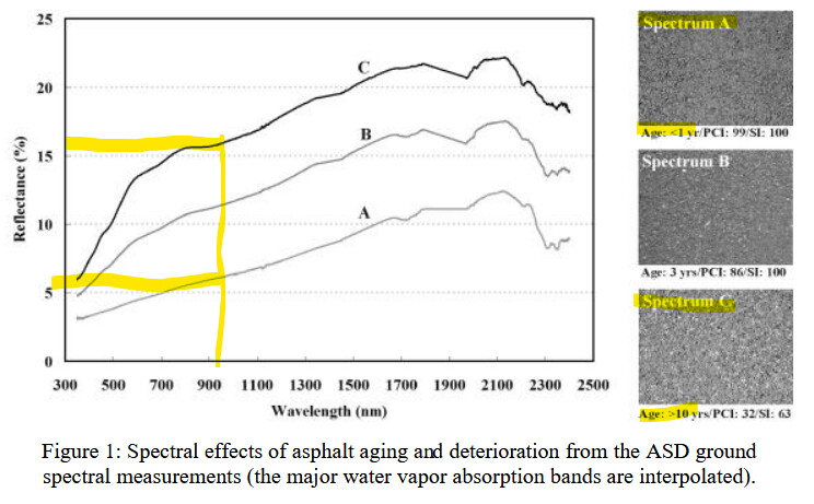
Asphalt roads are difficult to capture since they average around a 10% reflectance at 90 degrees. That trails off to zero as the laser tilts toward oblique angles of incidence. Additionally, hot surfaces and moisture (like AM due) can make that worse as well. Hot roads can bend light and worse, will bring up the oil film that swallows/scatters the laser pulse. (see pic)
Bottom line is new or “shiny” asphalt roads can be really hard to capture in most LiDAR systems. Best fix… is to fly low (more laser energy hitting the pavement) and slow ( more chances to get a return) or get the road colder and/or dirty/dusty.
some additional reading: http://www.geo-informatie.nl/Projects/Santa_Barbara_Urban_Spectral_Library/urbanspec/understanding_asphaltspectra_web.pdf
If your control is narrow or small… also consider the foot print of the laser beam on the ground… GCPs need to be pretty large (18" radius, 4" wide features) for it to show up well in LiDAR. Many are familiar with GCPs for photogrammetry, but GCPs meant to be seen in LiDAR have a few different best practices.
Hope that helps, feel free to clarify your frustration if I simple miss interpreted your question.
3 Likes
@Athena if you are using the newest firmware you’ll also be able to turn on high sensitivity mode. This is usually only recommended for an AGL over 100m but if you have fresh black roads it might help you to gain more point density. Also keep in mind that high sensitivity mode also increases noise at lower altitudes so some testing is advisable.
1 Like
I am using the new firmware. I will give this a try again after the weather clears up in my area. Thank you so much!
Thank you so much! this helped me a grate deal! I will try your advice once the weather clears up here in my area.
Weather has been crazy lately! Let us know how things are moving along.
Oh, and by the way did you set up your ROCK Stars account? I’m sure we would all love to see some scans from the Philippines.