I am looking it purchasing one of these systems but have questions regarding the software and the process of extracting a Tin, or DTM to provide to a client. As a Professional Land Surveyor we often have to manipulate a .tin file to accurate define tops, bottoms, breaklines etc. as part of our deliverables. We are also required (in certain jurisdictions) to ground truth a certain percentage of the data before we certify to a client, engineer or regulator agency.
Within the software do we have the ability to define breaklines or add additional data to the cloud and regenerate the surface?
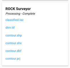
Great questions, Cory. Currently, RC (Rock Cloud) exports the deliverables from the Surveyor Processing Package in the following format (img below). So the contour is in ESRI Shapefile format and the raster DTM will be a TIF file.
Currently, RC doesn’t have additional editing tools for refining the deliverables, not yet. Therefore, you would need to perform the additional improvement, if needed, in another software. Moving forward, however, we plan to continue to boost the functionalities of Rock Cloud and more tools will be added.
Virtual Surveyor is good for adding breaklines to generate a Civil 3D surface. I started using it for photogrammetry projects and now using it for lidar.
What would be very helpful for creating a full design grade surface is to have all the points used in creating the surface, breaklines, etc in one file. The 10 ft dtm is great but I need all critical things in between. Right now I’m loading the DTM into Virtual Surveyor to create points, then mixing those all together with our survey field shots. If I had the actual points used to create the contours in the Rock Cloud, I could mix field shots and drone lidar in very little time. We are manually surveying the curb and critical design surfaces because sometimes the drone just can’t see through debris, silt fence, etc that can limit the lidar data.