Check out this awesome video showing how the new ROCK R1A LiDAR works on the DJI M300 drone!

Check out this awesome video showing how the new ROCK R1A LiDAR works on the DJI M300 drone!
Hi I’m from nepal and seriously thinking about incorporating lidar systems. Today I had a discussion with some experts regarding feasibility of lidar with drones. They said that lidar with drone is not feasible in nepal due to its hilly terrain. They said that they performed lidar using helicopter and the cost is super high. They said that using drone was very risky due to gsp signal being lost and the drone being lost in due process. As we know that for Livox 40 the optimum flying height is 75 m, so this would not be feasible flying this low in this terrain. I feel that it doesn’t make sense and therefore need your expert opinion in this case.
I have emailed you a line profile for a power line to get an idea of the terrain being discussed. Waiting for your positive response.
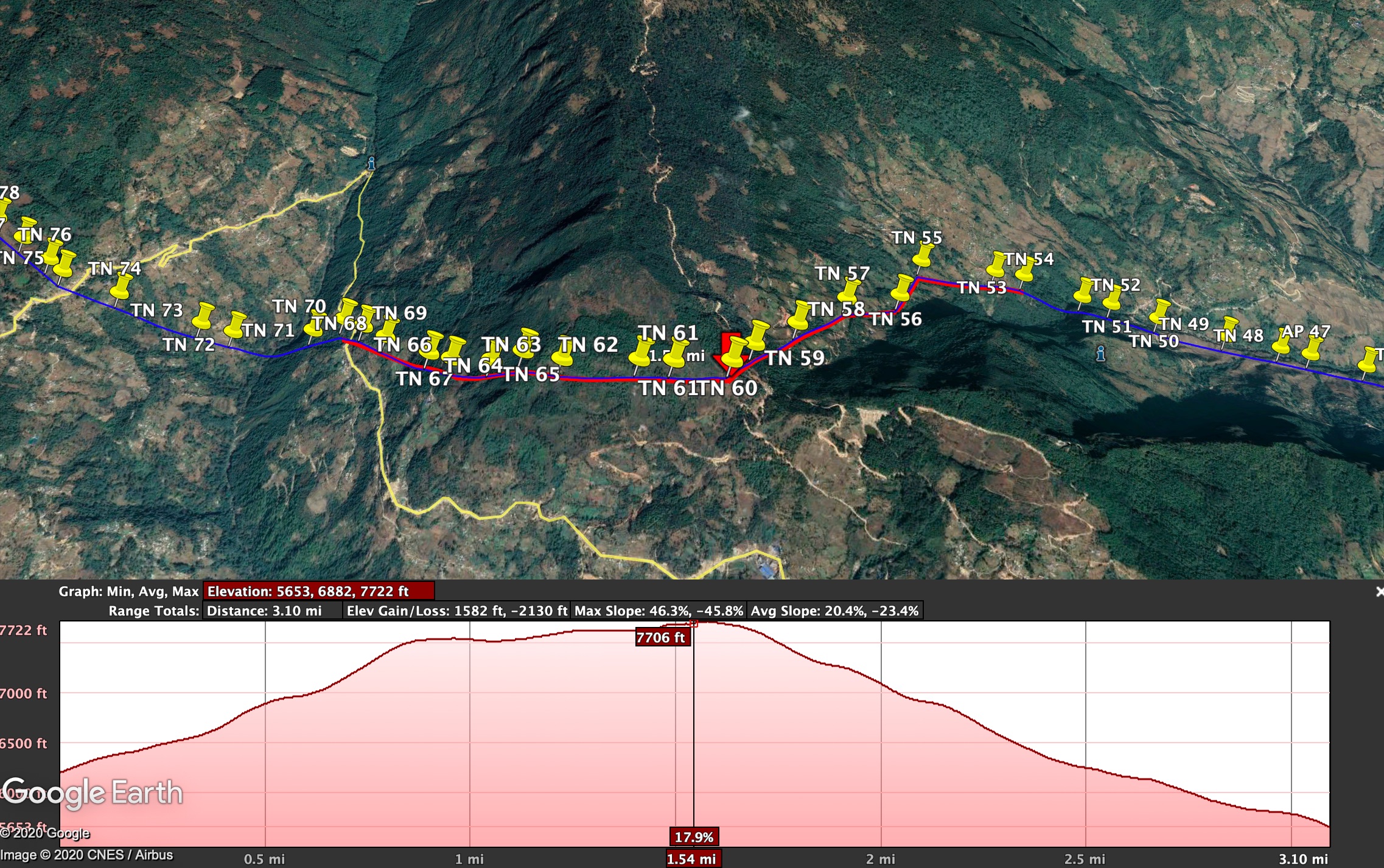
Thank you for your question. I have had the opportunity to look over your KML and analyze the flight path based on if I were to fly this mission. Below I am including a screenshot (with all geolocation removed) of a small section of the Transmission line to be inspected.
For reference, the question asked referred to a Transmission Power line corridor mapping through mountains with a total distance of about 40 km.
Using the R1A on the DJI M300, this job is certainly doable. I searched through the path and there are numerous places to park a vehicle and fly a 4 km section in both directions, then move down the corridor to your next flight location.
i would not be concerned about losing GPS/GLONASS/BEIDOU signals. You will have enough clear view of the sky at 75 m to not affect your flight performance.
For a reference, flying the DJI M600 with the Riegl LiDAR, I fly 3 km out and 3 km back with no issue. The M300, I am confident to fly 5km out and back without issue.
At an AGL (above ground level) of 75 meters, I also feel confident in the 3D flight planning software to safely guide the UAS without collision with the terrain. Additionally the M300 has obstacle avoidance on all surfaces, so you will not need to worry.
to capture this 40 km segment, I would estimate 5-7 days to safely fly the entire corridor.

Thanks Harrison, feeling much better after hearing. a positive response from you about the viability of using drone for lidar survey using R1A.
As for the time to do survey for this 40km, u mentioned it would take 5-7 days. You said that we could fly 3 km in both directions so that would be 6 km from one take off location. As per our earlier discussion, I thought we could easily do 2 flight mission from 2 take off location per day, that would equate to 12 kms per day. Based on that it would take max 4 days to complete. Could u explain why u mentioned 5-7 days. Also could you tell how long would it take to set up a location and fly 3 kms in both direction.
To be more confident, I will send a few more power line route alignment in nepal. Please could u check if it is possible via R1A.
Thanks.
Absolutely! The reason behind 5-7 days is assuming weather, travel, etc. The actual flight time can easily by achieved in 4 days. The actual flight time for the 5km out and back (10km) is only about 30-40 minutes. I would personally side with caution and only push 4km out and back (8km) per flight and land with 20-25% battery left in these scenarios.
I will be testing the M300 for optimal flight planning in the coming weeks and will have more specific insight into the flight planning details.
So, if you take my assumptions. 4km out and back, is one flight, and repeat this the other direction. Then at each takeoff location you can get a max of about 8km. It is very reasonable to do this in 2 locations per day. This puts you at 16km of powerline inspection per day in this terrain.
Now, when your crew gets more familiar with the equipment and is operating with confidence, I can easily see a 2 person crew doing this 4 times in a day (on a good weather day) … 32km in a day
My summary would be between 8-40 km in a day. 1-5 days!
Definitely an accomplishable task, and this also applies for other linear right of way ROW inspections.
Thanks for your quick response. As for the processing side, how long would it take to get the point cloud and I presume this would come under the monthly charge of 200usd. For the 40km power line survey, what will the size of the data be? Could you provide me the cost and time to post process if I just wanted a simple contour map to convert into autcad for design purpose.
Also could tell me what other output options do I have from your cloud service and the cost related to it.
Thanks.
Yes the point cloud processing is covered by the 200 USD a month. If you needed contours this would require additional cost. I will capture a corridor dataset and measure the average data at the 75 m to get a good estimate. I will come back to this.
We can offer transmission powerline classification. Classify the Tower, Conductor, Insulator, and Shield(Ground) wire. This classified dataset can then be used to analyze the condition of the transmission assets and measure tension in the wire inside other software, such as PLSCADD.
This additional transmission processing is not available on our plans yet and would need to be covered in the Enterprise “Contact Us” pricing.
Can R1A system be used with the DJI D RTK 2 base station? On a seperate note, I’m buying a DJI P4 RTK for photogrammetry drone survey. Would you recommend me buy this or is their solution I should look into.
Thanks.
Hey Tenzin,
I would definitely recommend the P4 RTK! Great piece of equipment. As for the DJI base station, last time I checked, there is no way to record the static RINEX observations. Therefore the system only works in real time and does not allow for post processing. Until this is changed, it will not work for the ROCK cloud.