Something I have heard from quite a few surveyors in my area is, “We don’t know what to do with the data and use an old version of AutoCAD.” Specifically, my last conversation was with a surveyor using AutoCAD 2007 but is interested in if I can help them import the data. Has anyone had any experience importing the shapefile and converting into the older version?
Maybe a subtle encouragement to update?
1 Like
Haha, that will be step 2! They are very reluctant to use the data in the first place because of the unknowns. I’m going to make this my personal mission for now because it’s three surveyors as of now that would like to give it a try but have outdated software. I may need to find another surveyor to partner with to help with drafting. What do you think?
In my evolution with RPAS, I would not be where I am without my team. No ONE person is a master of all, it takes many talents to make Lidar data sing, and sing loudly.
Outdated software and the mission you have before you is a challenge, but one worth taking on; it always gives me a warm fuzzy when individuals, who finally understand what the data does, their eyes light up and you can feel the excitement.
On a side note, its very frustrating dealing with those companies who forgot to update. Are they still on windows 7? LOL
Lol, very good question! Well, even if they are still on Windows 7 I am motivated to help them understand and be able to use the data. They are a well known and respected company where I’m from and I’m happy they are showing interest and want to entertain the idea of using the data.
I think you can import your shape file or dxf/dwg into Global Mapper and export it on the desire autocad version.
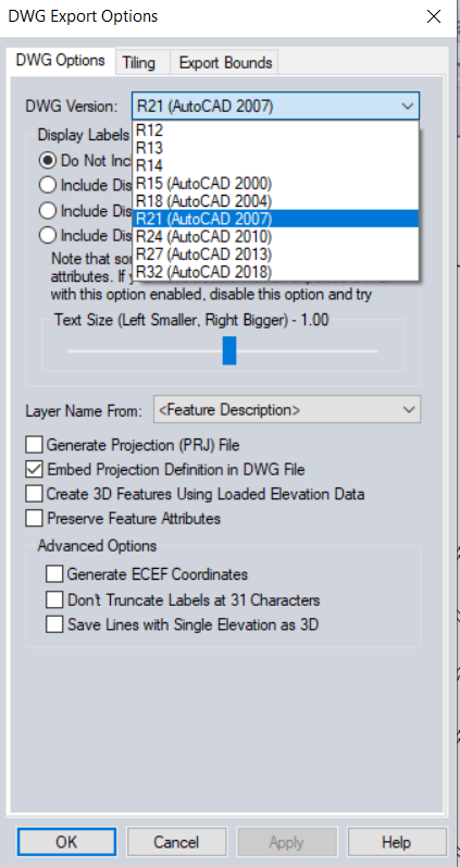
This looks like it may be the best option ![]()
![]() Thanks so much for sharing and I will let you know if this works for them.
Thanks so much for sharing and I will let you know if this works for them.
1 Like