Is there a way to get a surface classification las file from the survey point cloud? Would be helpful to have a small file to import into civil3d.
Thanks
Is there a way to get a surface classification las file from the survey point cloud? Would be helpful to have a small file to import into civil3d.
Thanks
@Blacksix just so I understand correctly, you want to be able to download the las file which includes points that are classified as X? (in your situation class 2)
Yes, the file would be just class 2.
@Blacksix adding to our development queue. Thanks for the feature request! We should be able to have it available within the next couple of weeks!
Outstanding, it will be a great feature for surveyors. Of course give me a heads up when it goes live.
I am awaiting delivery of our R2A. This feature is something I was hoping for as well!
Thanks!
Stay tuned! We think you will be pleasantly surprised in the coming weeks.
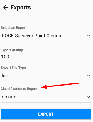
New to this, need help, I thought that is what we were getting when we process the Rock Surveyor, just the ground (class 2)? If not, this would defiantly be a great help!
When ordering the Rock Surveyor, you are getting ground classified, I believe this request is to be able to download only the ground classified points, instead of the whole dataset with ground classified. Hope that clarifies.
Thanks for the update. Looking forward to using this feature soon!
I haven’t tried it yet, but I will today. Thanks
could we get it changed to add more than one? Basically I’d just like to import ground and road surface together so I can include the crown of the road in the surface in one step.
@Daniel yes. Multi-select will be released soon.
@Daniel multi-select is released.
Cheers!
Light speed! That’s a cool feature…