Our new facade mount arrived in the mail today! I am so excited to try this out, I can hardly wait, but I must… (the wind here is 50+kph/30mph sustained, gusting 60 knots)
I would assume that the initial/overall workflow for lidar data capture with the R2A has not changed. I will mount the unit, initialize, take off and complete my 2 figure 8’s… complete my facade scan using tips learned from Matt and Harrison’s bridge survey!
Are there any tips/secrets you can share for image alignment when we process our facade data?
Thanks Rock!
Cheers!
1 Like
Mine arrived, also so itching to get some missions done. You’ve covered same questions I had…except one (from the same bridge video). I think he mentioned flying under the bridge w/R2A mounted on top to M300.
Q: how did flying under the bridge affect the processing, since this would be non-GPS area?
THANKS!!!
Be sure to use the auto CG calibration on your M300.
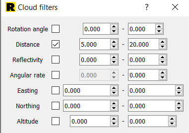
You will likely want to play with your range gate values for higher accuracy.
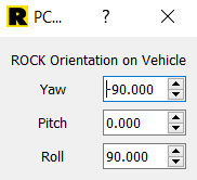
You will need to change your orientation in PCPainter. PCMaster can auto resolve to this, but best practice is to set the orientation in the GUI before you start your collection.
Yaw = -90
Roll = 90
You can venture into GNSS denied environments a bit, and the IMU will carry the data. Best not to linger though, and it helps if there is still some view of the sky.
planning on top mount, inverted and fly under a bridge (no view of sky). Any suggested settings, etc. for top-mounted processing?
THANKS!!!
I don’t know your answer, but I do know this:
My first scan’s adjustments:
Yaw +90
Pitch -180
Roll -90
So maybe yaw 180?
Good luck… please post your results!! (I am just loading my first scan in now)