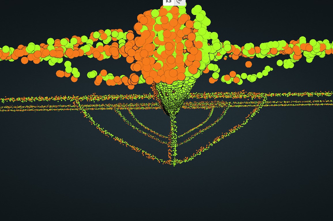
has anyone seen their data not lining up in a forward direction… as in when we fly one direction and turn around and come back the cloud is not lining up forward/back direction. it is lining up great left and right. here are some screen shots (GPS Time) of what I’m talking about. and yes, we are doing all the calibration and ending procedures correctly… we run 2 Emlid bases each flight, and I get the same results when processing with either base station. and we are flying the R360.
1 Like
Hey Josh,
Lately i have noticed that the boresight corrections are not perfect in the R3Pro V2 as well, this is most likely coming from the Rock Desktop processing software. We use L360 in post to extract ground points and other deliverables, it also also us to calibrate the boresight further and in some cases it makes a significant difference in the quality of the result.
What you could try doing if you do not have access to a post processing software like L360 is calibrate the LiDAR using the Rock Destop. You can find the option in the same step and place as you would for calibrating the camera. What you will need is targets or features on the ground that have high reflectance to the laser so it will be easy to pick these features out in different passes. When we initially got our R3Pro V2 the stock calibration gave us a very poor result but, by running the LiDAR calibration it was improve drastically. We still perform boresight checks in LiDAR360 but now find minimal adjustment are usually needed.
1 Like
Vashaun,
thank you for the insight.
that’s what I’ve been thinking was to look at the boresight. however, it seems as if the longer the collection time the worse it gets. as in the first several minutes of collection everything seems to be fine and then as time goes, I notice the gradual increase in error. I realize that I may be speaking to my ignorance to the boresight process while saying this. I did try a “LiDAR” calibration and had no luck. although I was trying to calibrate to the transmission towers. I need to setup a bunch of targets and do another flight and possible try a calibration that way. I have submitted a request to Rock Support, and I know they are looking at it. I just wanted to reach out in the community and see if there were similar issues. we haven’t always had this issue. Seems like it started when the desktop update to handle the dongle came out. I’m in the process of re-processing data from dates prior to the dongle update to see if I get the same issues I’m currently having.
1 Like
I’ve been flying large, multi battery flight with the r3 pro v2 and not seen this issue.
As @vashaunhenderson mentioned, I also check and adjust boresight / strip alignment using third pary tools (I used Terrasolid), but there is only minimal adjustment required, certainly not visible as in your image.
Ive recently switched to dongle also and data is processing fine.
Are you on latest firmware for r360?
What height / speed / overlap are you flying?
Final suggestion is to clear logs in the rock desktop, reprocess and then send the log file to support.
They will give you a link to upload the data so they can investigate.
Thanks
Jason
Jason,
I do have data submitted to Rock support and waiting to hear back.
I’ve only noticed this issue over the last couple of months and it gradually getting worse and the other day it was considerably worse. back before the dongle all our flights look great. kind of like you mention very little to almost no boresighting needed so I haven’t worried about it.
as the flights progress the error grows. as in there is not a constant error that can be corrected with boresight. it feels like a timing issue.
I do have all software/firmware up to date although I noticed that Rock rolled back the latest version of desktop yesterday. not sure why but they did.
we fly most of our transmission line projects between 160’AGL and 180’AGL with a speed right at 5m/s (11mph). we have been flying for a little while now and have +/-100 completed projects with the R360 and just now seeing this issue. I know we send in our Leica terrestrial and mobile systems once a year for calibration and such but we have had the R360 for 2 years and haven’t had issues until now. there used to be a section on the knowledge page on how to boresight the R2A but I no longer see anything on doing it for the R360.
if you don’t mind talking, I would like to pick your brain. my email is jburge@ga-inc.net. we can exchange number by email.
Rock Desktop v1.13.38 got rolled back as there was an issue with trajectory processing, point clouds were totally out of alignment.
I fly similar configuration to you also.
I wonder if your r360 is faulty?
I’ll contact you on email. Happy to attempt a strip alignment for you to see what happens.
Jason,
I just checked this and I may have deleted your email if it was in my junk folder. I don’t typically look there I just delete them. if you don’t mind sending me another email jburge@ga-inc.net , I would greatly appreciate it. we’ve had this R360 for 2 years now and I would imagine there is some calibration other than the camera that needs to be done. I also heard back from Rock support yesterday afternoon and basically was told to do smaller flight lines. the most we will do is a mile one way and until recently we haven’t had any issues with data. in fact, I flew a job a couple weeks ago and the longest flight line was 700ish feet, and I saw the same results. again, the left, right and vertical of each overlapping trajectory seem to be pretty good it just the forward/back that is getting worse.
we flew another job yesterday and it’s even worse than ever. something has to be faulty, IMU, software… something.
I sent the guys out to fly the job from yesterday again but I’m having them break it into 2 smaller flights as rock suggested to see if that makes it better. I’m not so optimistic about it.
I wonder if there is some kind of flash we can do to the system and reset it. I have the original boresight flight that rock did before they sent it back to me.
Hey Josh,
Check you processing report and see if the final lever arm is being calculated, i have noticed that some of my missions lately have been not calculating the final lever arm which can lead to poor alignment quality.
1 Like