Hey All,
Checkout Harrison’s latest video on how to classify point clouds in ROCK Cloud! This LiDAR Drone does it ALL + special reveal at the end! - YouTube
Enjoy and let us know what you think!
Hey All,
Checkout Harrison’s latest video on how to classify point clouds in ROCK Cloud! This LiDAR Drone does it ALL + special reveal at the end! - YouTube
Enjoy and let us know what you think!
Is this only for new projects and it is available for all users of the Rock Cloud? Also, can we derive ground Contours from this feature or no?
Thanks!

I did this today and it worked great. Ordered Rock Surveyor yesterday, had a few points that needed to not be classified as ground, I fixed in about 5 minutes then it reprocessed very quickly.
Thanks Tim. Can you also clarify something for us?
If we decide to upgrade to the business plan, will these new features allow users to generate contours without processing via Rock Surveyor?
No, that’s part of the surveyor package. This simply allows you to select an area and change it’s classification manually.
Does Rock Robotic have any plans to make this accessible for all plans? It seems this would make sense as end-users still have to process files via the Rock Surveyor.
At initial release time it’s for business accounts only. That could change over time, but not in the foreseeable future.
This new feature is awesome!
What power we have over our initial data outputs!
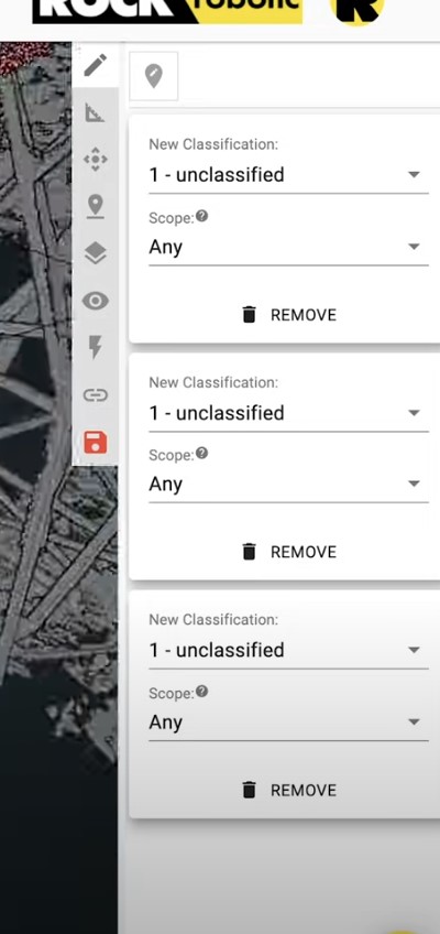
Silly question maybe…but my cloud interface looks different from Harrisons. It doesn’t have the same features and we are on the Business Plan. See image comparisons
Those tools are dependant on whether your looking at multiple projects in the compare view and also you need GCPs to use the auto align tool.
Thanks…and the classification tool? I’ve never really known what to put in the “from class” in our projects yet. But the example in the video shows different verbiage (“New Classification” and “Scope”) Just wasn’t sure if our interface was different for a reason whilst trying to teach myself.
Good eyes! We updated the verbiage from the time Harrison released the video until now to help clarify.
“From” is helpful is you want to only change one class to another. Ex: Change only “Ground” to “Unclassified”. Then you don’t risk editing “Low vegatation” or other unclassified points.