400 Acre site guidelines

Terrain follow is a feature of DJI Pilot for the M300. It was recently updated so that it’s fully functional. However it is not thoroughly tested as of yet, so you still want to be mindful of your height when using it.

You shouldn’t have to use RTK in order to utilize terrain follow as the DTMs are built into the world map. More info on that at a later date. Happy flying!

Thanks. Do you think my camera settings are correct? Appreciate if!

Wanted to drop in and offer this: I just flew a 400+ acre site on some really low parameters- the goal was not survey grade topo but I’ll probably still get that level of accuracy after the processing finishes from the looks of it.

I flew at 400 feet. No terrain following
20 mph
30% overlap

So far the data seems perfect for our deliverable which is “GIS Level” topo. I noticed on one side of the project a control point was .2 ft off - no big deal at all.

1 Like

This is fantastic, nicely done sir! If you ever have any jobs like this that you’d be willing to share on the community please don’t hesitate to share a link.

Is this still true with updated firmware on remote and m300 rtk? I have a project that will need terrain follow.

So I still seem to need a DSM file on my SD card or on internal memory for Terrain Follow to work.
To get that

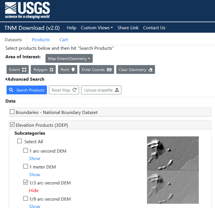
  1. I went here: https://apps.nationalmap.gov/downloader/#/
  2. select the 1/3 arc sec DEM (just right density for M300), click search products and download it (geotiff).
  3. use your preferred GIS to clip it down to ~4sq miles (to fit within the M300’s max dsm file size).
  4. upload the geotiff to your controller and select that file.

it will calc it out and give you a color spectrum on each flight line.
NOTE: I have only planned with this so far… first Terrain Following flight is early next week… :wink: That said this is the DSM I have been using on our phantom drones (via Map Pilot).

EDIT: make sure you get an area a good bit larger than your flight area… I’d hate to think of what would happen should your drone ‘fall off’ the edge of the DSM surface… :slight_smile:

1 Like

Nice write up @anthonyhermanklj

What do you personally use to clip your .geoTIFF file?

Don’t suppose you’d like to do a similar walkthrough for that as well?

Thanks.
Engineering firm so we use ArcGIS Pro (ESRI). Their instructions are better than what I could write (link below), the only difference being drag a kml polygon into my project and can directly reference that in CLIP or EXTRACT rather than having to draw or convert something into a .shp file. I do the same for the created Point Clouds from PC master…

I know there are free ways to do this (the raster part), but ESRI is where I first learned and have since stayed.

or I hear QGIS is free and can do this…

do I interpret this as all we have to do is select “Terrain Follow” feature in the Pilot/Mapping app…and we don’t have to import any DEM file?

If I’m incorrect, please supply specific steps then.

THANKS!!!

See @anthonyhermanklj post above. It gives a pretty solid explanation of how to do this.

1 Like
  1. Obtain DEM…
  2. Load DEM.tiff onto the remote’s memory (I just made a permanent folder on the SD card we use in it).
  3. In the pilot app, select “terrain follow”. That should open an area below it to select or upload the DEM
    image
  4. From the app, browse to the folder you placed your DEM.tiff and select it.

It should show a screen like this:
image

Should be good from there… but sorry that’s all I can recall from memory (don’t have the drone at the moment).

1 Like

Thanks! I got it all working.

1 Like

So it says in remote to enable rtk before performing terrain follow. Necessary?

Hmm, must be updated… but no, not necessary unless you are flying really close in… or have really tight vertical tolerance on your capture… ie flying at 299ft in a 300ft cap… :wink:

Come to think of it, one of my other pilots said that came up for him as well. but it collected/flew just fine without. RTK would just give the nav computer more accurate positioning… has no impact on the R2A or any other independent sensor.

If I’m not mistaken the AGL of the M300 is based mostly on air density. Therefore if it doesn’t have the RTK it doesn’t have a tight reference to the ground. You will notice this in your PCMaster trajectory, when you do a battery swap. When it continues a flight line it is often at a different AGL than it was at prior to the battery change. It’s usually close, but often off vertically. I have personally noticed no ill effects from this with pre-processing and it’s usually so close vertically that you won’t even notice.

Note: Technically you can use the Reach RS2 as an RTK Base for the M300 if you have an active SIM card installed and it set up correctly. Kind of a bargain at 1/2 the price of a D-RTK Base.

Thanks for the info. After four days I finally have the DEM/ terrain follow set up in the remote as well as a mission all set up in ugcs. Final verdict…I like that I don’t need any additional stuff using the SRC. Is there any real benefit to using the ugcs, with laptop, wifi etc. or will I be ok with the DEM on the SRC and the normal rock robotic workflow.

Cool! do you know of a setup/config process for that? (ReachRS2 as RTK)

Positives:
Real time editing of your missions
Telemetry data
LiDAR specific flight parameters (smooth elevation changes and turns)
Easy import of DEMs
Automatic Figure 8 Patterns and hands free operation of missions

Negatives:
Laptop + WiFi Hotspot + RC and power sources for all of them is A LOT! It is definitely a package suited for a vehicle command center vs walking
Connectivity can be hit or miss sometimes
Engineer Built, very EXTRA for most uses with a steepish learning curve
You can’t edit your mission on anything BUT a laptop

Personally I’d love to see UgCS with the ability to have an iPad running the client and broadcasting the hotspot. That would make things much much easier and the whole thing a lot more convenient. I dunno if that’ll ever happen though. I’ve asked them about it before with not much in the way of a positive response.

@Harrison is the only one I know that’s done it. I haven’t had time to test it yet myself. It seemed to work pretty well for him though.

1 Like

Harrison is the only one to use the SRC with terrain follow and DEM workflow?